 |
About Zakho |  |
It is one of the important territories in the region and considered
to be the gate of the region to the external world. Zakho city is the
center of the territory which lies on the south- western side of the famous
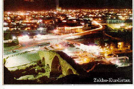
plain of Sendi with fertile soil, Zakho is a beautiful city characterized
by a lot of water and nice climate, lies on Khabir river which passes
by and a branch from the river divides the city into two parts and there
is a stony bridge on it, almost was built in the reign of Badinan Emirate,
then the branch meets with the main branch which passes by an ancient
castle, in the castle, there are a bench of eight angles, columns above
them sharp curves and decorations, they made the castle as house for their
princes.
The historians have disagreed about its name and there are several
stories or opinions about it, in some Arami sources the name of the city
is mentioned which is derived from the Arami word (Zakhota) which means
the victory in relationship with the battle happened between the Romans
and the Persians near the city and ended with Romans victory.
The history of the city is accurately unknown, the prince (Jaladat Badirkhan) has mentioned that it was an important city in the reign of Kwiteens. It is certain that the Greek leader (Zeyzafon) passed by the city in (401 BC) when he pulled out his army and he mentioned the Kurdish citizens of the city when he returned home with his army.
The Kurdish historian (Sharaf Khan Badlissi) (1005 H) mentioned that it belonged to Badinan Emirate since the days of Sultan (Hassan Beck son of prince Sayf Deen) and appointed as the first prince to the city on their behalf in (892 H). One of the princes built a church for the jews in the city and still its remains are clear and in sight.
The people of Zakho depend on agriculture to earn their living specially the winter crops like wheat, barley, chick- peas, various types of peas and beans and different kinds of fruit trees by exploiting Sendi plain and other flat areas which can be benefited from them beside the summer crops like tomatoes, rice, tobacco, other types of vegetables. Zakho territory is well- known in growing trees such as populus, wal- nuts, pomegranates. The production rates are very high because of the fertility of lands and the availability of fresh water. The city was also considered to be the main source of making and exporting the folklore clothes (Shall and Shapik) but it started to shrink because of the shortage in the materials used in making the clothes and men shifted to wear clothes made of different types of cloth. The city is regarded as the gate of the region to the external world therefore it becomes an important commercial center and the majority of Zakho people work in trade and there are many trade companies in the city. Zakho city is full of historical remains, Duhok Archaeology Office listed (15) archaeological locations and they are:
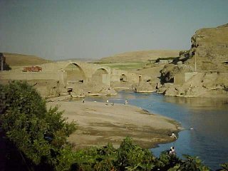
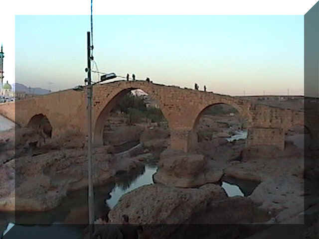
This bridge is erected over Khabir river to the east of the city. There are different stories or opinions concerning its construction, (Hamarteen) says it is Roman, (Asskeef) says it is Greek and one of the leaders of the great Alexandar AL- Makadoni his name was (Slowkas) ordered to erect the bridge and some of the archaeologists in the Iraqi General Directorate of Archaeology think it might be erected by one of the Badinan Sultans but it is certain that the new bridge is erected on the remains of the ancient one. We think that one of the Badinan princes renovated it and repaired what was destroyed from the bridge. There is a famous epic in the from of a song in the Kurdish language about the construction of the bridge. The length of the bridge is about (114M), the width is about (4.70M) the height from the water surface is about (15.50M)it is erected by carved stones and consists of a wide and high curve in the middle and other smaller curves on the sides totally they are five curves. The walls are built by carved lime stones and they are put together in a beautiful and decorated way by using lime for plastering the walls. The history of Pera Dalal construction can not be identified because there are no signs, statues and writings on the bridge to show its erection date. Pera Dalal is an ancient name called by Zakho people, in some sectors they call it (Pera Mazen) mean the great bridge. It has another name which is ( Aabassi bridge) it is a new one named at the thirtieths from this century by an official order from the Mayor of Zakho at that time, the archaeologist (Conrad Brouice) mentioned it and visited it in 15th of April, 1909 under name of Khabir bridge.
2-Zakho castle
It lies in the city center on the western of Khabir
river and it is still in sight, it was the governing house in the reign
of Badinan Emirate but the prince (Ali Khan 1205- 1212H) renovated and
extended the castle. The castle was erected on the ruins of an older castle
because the remained parts indicate that it was a strong and hard castle
built by big pebble stones and coated with gypsum, still there is a huge
tower erected by sequared stones still in sight.
3- Qubad Pasha castle
This castle situates in the cemetery of Zakho,
it has a hexagon shape, six windows and a gate as an enterance. Eathenware
and lime were used in building and plastering the castle with writings
and pictures on it but they are removed at the present time.
4-Kesta remains
Kesta was an ancint city, its history belonged
to the Assyrian periods, since Assyrian, Greek and Islamic coins and statues
were found in this city. The late Shamdeen had written about Kesta remains
in Ikha magazine in May, 1933 and about other archaeological locations.
It is far from the governorate center in abour (58)km. The territory area
is about (1378) sqkm and contains three districts, they are:
Rezgari district
The center is Ibraheem Khalil town, it is considered
to be the main enterance of the region to the external world in which
an international road passes by the town to Turkey.
The district center lies close to the meeting
point of Heezal river to Khabir river where the international bridge passing
by Turkey. The name of the town came from the village where the tomb of
the father of the prophets (Ibraheem Khalil) is found. It is considered
to be a tourism area in itself and a recreational ground or a general
park specially for Zakho people and for the whole governorate.
The people depend on agriculture specially winter crops like wheat, barley,
chick- peas, lentils, gram and others even in an insufficient way beside
summer crops like tomatoes, rice and all kinds of vegetables also growing
fruit fields, (lefi) area is famous in fruit fields specially in growing
fruit trees like (Armishte) pomegranates, various types of grapes, peaches,
apples and olives which are considered to be an ancient crop in the area
by getting benefit from the water of Khabir river.